ADI - Analysis-Design Interaction
The Analysis-Design Interaction methodology (ADI) was conceived and developed by Professor Gianfranco Moneta’s research between 1980s and 2000s within CIRTER (inter-university research centre about territory studies) and his module of Architectural Design at the Faculty of Architecture of University of Rome “La Sapienza”. ADI was conceived as a tool to read and interpret the natural and anthropic elements of territory, their process of use, reuse, and transformation, with the final goal to use these elements for sustainable urban and architectural design. This methodology is rooted in the longstanding research of Italian architect Saverio Muratori who put the basis, between the 50s and 60s in Italy, for a morphological school of urban design and studies on anthropology of the territory that are becoming relevant today in the quest for sustainability.[i]
ADI is rooted in Muratori’s urban morphology approach, and further research of his disciples G. Cataldi and G. Caniggia in Italy, and M. R. G. Conzen in UK on typo-morphological analysis.[ii] ADI in fact, considers the form of territory and settlements as a temporary phase in a never-ending process of transformation, where the environment acts as a stable heritage of the civilisation. ADI is aimed at reading and understanding the historical structure of territory and settlements as integral part of the character of the place (Genius Loci) through a diachronic and synchronic analysis. These two analyses, combined together, could then be used to interpret and design a territory, an urban settlement, an urban space.
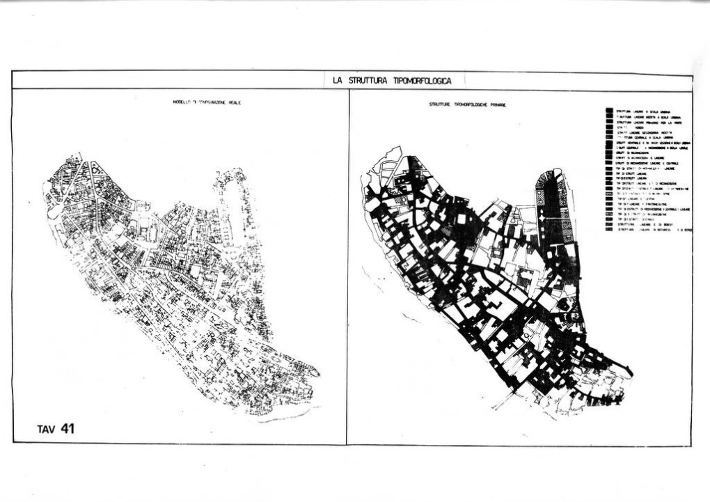
ADI methodology is able to go beyond the present chaotic picture through a morphological analysis which follows the evolution of the territory and settlement; thus, identifying new sequences of meaning, new material and immaterial spatial configurations which are truly sustainable and respectful of places because conceived in a critical relationship with history and memory. The design activity in ADI is directly connected with the analysis and it is here considered as an action of use or re-use of the place/territory and its components; some components are present at the moment of the activity, others are no longer visible, but they are still conditioning the actual state of the place/settlement/territory. Analysing and revealing models of use/re-use of the territory, ADI identifies the form of transformations, a crucial aspect that can inform -at different scales- both urban design and architectural design. The models are characterised by the Parts (Elements), understood as territorial organisms in themselves, interconnected by the system of connecting relationships. In order to grasp the dynamics of the transformations of the territory ADI includes a diachronic reading, and then a synchronic reading to grasp the typical natural and anthropic elements, their degree of permanence through the process of use re-use transformation, in order to use these elements as basic materials of the project. The place is therefore interpreted as a landscape, understood as a structure, defined, according to the principles of Landscape Ecology, as "a system of interacting ecosystems in a given environment".
ADI methodology phases are:
1) The territory considered as a global architecture: the aim is to ‘read’ the territory through an historical-morphological analysis of both territorial and urban areas’ transformations during the years;
2) Transformations and re-use: Morphological analysis the territory and landscape to identify invariant historical structures as a series of systems interacting with their continuous process of transformations, i.e. territorial grids, boundaries, settlements and pathways: ridge paths, half-ridge paths, valley paths;
3) Systems and sub-systems: Overlay of historical periods to understand the relationship between physical environment and anthropic systems, historically;
4) The structure of the element: To utilize diachronic and synchronic reading of models of use of places/territory to identify elements as particular form of transformation; This crucial phase is aimed at identifying the relation between systems and elements, to recognise models as structures of historical use of the territory that are still present, in whole or in part, in it; then, in the design project, to prefigure a reconfirmation, a reinforcement and reuse with new functions of these forms that thus constitute the basic material for the design process.
5) Between memory and future: To apply models of use and processual re-use of places in urban and architectural design re-utilizing historical territorial support and, at the same time, re-constructing a structure of interdependences.
Recent applications of the ADI methodology include the Tuscolana Project in Rome (2022-23) included in a research paper published in 2024 on IASTE Working Paper Series with the title: 'Investigating the “Altera Forma Urbis”, the Secret Structural Urban Form of Ancient Rome, By Applying a Sustainable Innovative Architectural Design Methodology for the Challenges of the Contemporary Built Environment'. Link to the publication: Vol-331-R.pdf (iaste.org)
References:
[i] N. Marzot, "Studies for an anthropology of the territory: New achievements from Saverio Muratori's archive." in G. Strappa, A. R. D. Amato, & A. Camporeale (Eds.), City as Organism: New visions for urban life, (U+D, 2016), p. 43-53.
[ii] G. Caniggia, G. L. Maffei, Architectural composition and building typology: interpreting basic building. (Florence: Alinea, 2001). M.R.G. Conzen, Alnwick, Northumberland: a study in town-plan analysis. (London, Institute of British Geographers, 1969).
Previous Research Projects:
An interpretation of the morphological roles of Rome, from the late Republican era to the early Middle Ages (2nd century B.C., 7th century A.D.), investigated through the study of road layouts
Elaborated by M. Crocco on S. Muratori (Per un Operante Storia Urbana di Roma)
This work is based on a methodology for interpreting urban phenomena, based on the relationship of continuity and opposition that the road layout establishes with the historical structure of the city and its constituent elements, fabrics, nodes, emergencies.[1]
The territory and the city as a structure
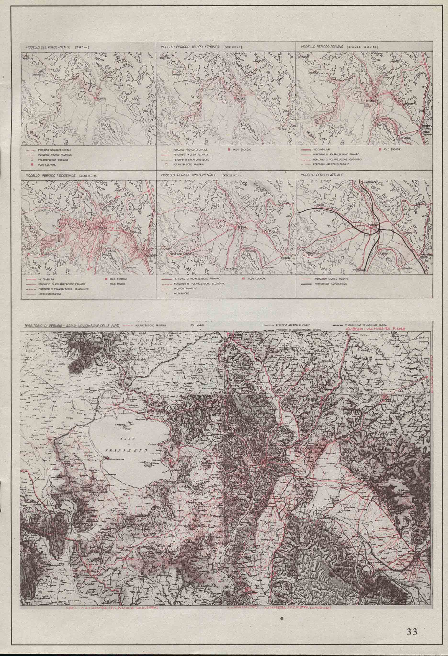
The morphological reading of the territory and the city in its development along the time, allows through the diachronic analysis, to control the different figures that, acting on the territory, constitute its primary figurative values: the hydro orography and the anthropic transformations.
The urban built-up area, its constituent elements: fabrics, nodes, emergencies, is closely connected to the linear system of territorial and urban routes. The road system, in turn, is closely connected with the hydro-orographic form in a relationship of adaptation and overcoming of it.
The hydro-orographic shape and the road system are integrated so that the orographic type - ridge, hillside, valley floor - automatically becomes the road and settlement type.[2]
Analysis of forms and transformations
The analysis of the forms present in the territory at the various scales, the interactions between them, make it possible to relate parts and functions of the territory in the dimension of Structure, a structure of interdependencies endowed with the specific conditions of identity and self-regulation. The historical structures are read diachronically in their incessant process of transformation and synchronically as a complex form resulting from superimposition. Form is conceived as a limit state of continuous processes of transformation. The structural interpretation of the territory and the city leads its themes back to those of development (diachronic dimension), Form (synchronic dimension) and interchange (functioning).
Rome and the role of the city-territory relationship
The oldest systems of routes and settlement systems on the peninsular ridge are present in Rome with the Etruscan Ridge System and the Latin-Italic Ridge System, which converge at the ford on the Tiber that gave rise to Rome.
In the first phase of the genesis of the urban structure, a system of radial centres was defined, facing the valley of the Tiber, connected by streets named after the centres themselves: Nomentana, Tiburtina, Gabina, Prenestina, Labicana, Tuscolana, Ardeatina, Laurentina.[3]
There is a close interrelationship between the morphology of the place, the type of road and settlement. Ridge routes generate ridge settlements, valley-floor routes generate valley-floor settlements and exchange centres at the crossroads of these routes, constantly located at the valley floor.
The close connection between place structure and urban morphology generates a typical resulting morphology. From the beginning, a hierarchy of routes was established: those on the ridge were of exclusive local relevance, while those on the valley floor were of local relevance when, together with the ridge routes, they generated the road junctions at the entrance to the settled area, and those of territorial relevance when they constituted the interchange structures between the various Etruscan, Latin and Sabine populations.
The structure described is progressively consolidated from the royal age to the imperial age.
The historical layout of the city up to the present day is largely the one that was consolidated with the model of use of the late imperial city, a layout that has remained almost unchanged in its "form", even if its functionality has in part declined.
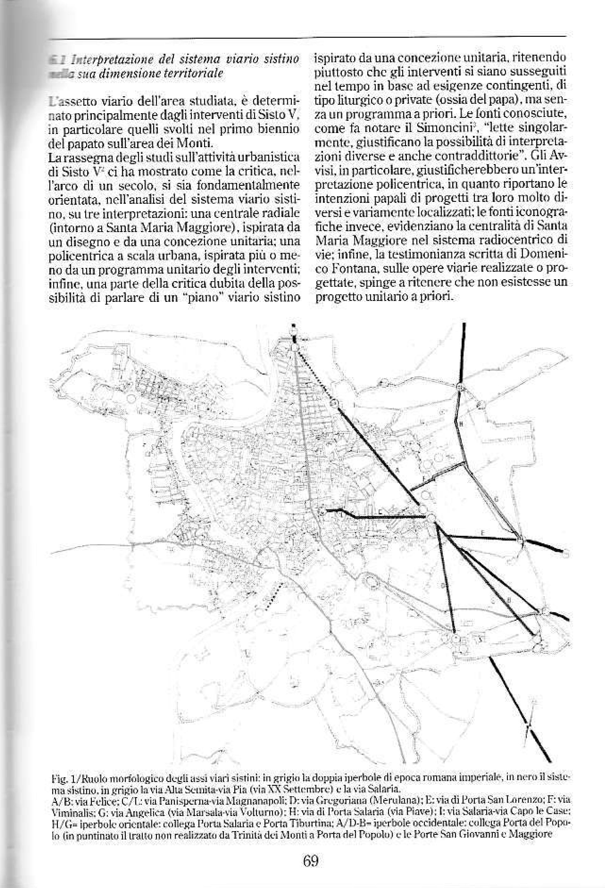
The typical form of the city:
From the origins, until the imperial age, the radial routes of the consular roads tended to connect progressively in a wide coordinated system. In particular, the eastern radial routes (Salaria, Nomentana, Tiburtina, Prenestina) were connected in a fan whose edges were formed, to the north, first by the via Salaria, in the royal period, and then by the via Flaminia-Cassia and the via Labicana-Campana (Casilina), to the east.
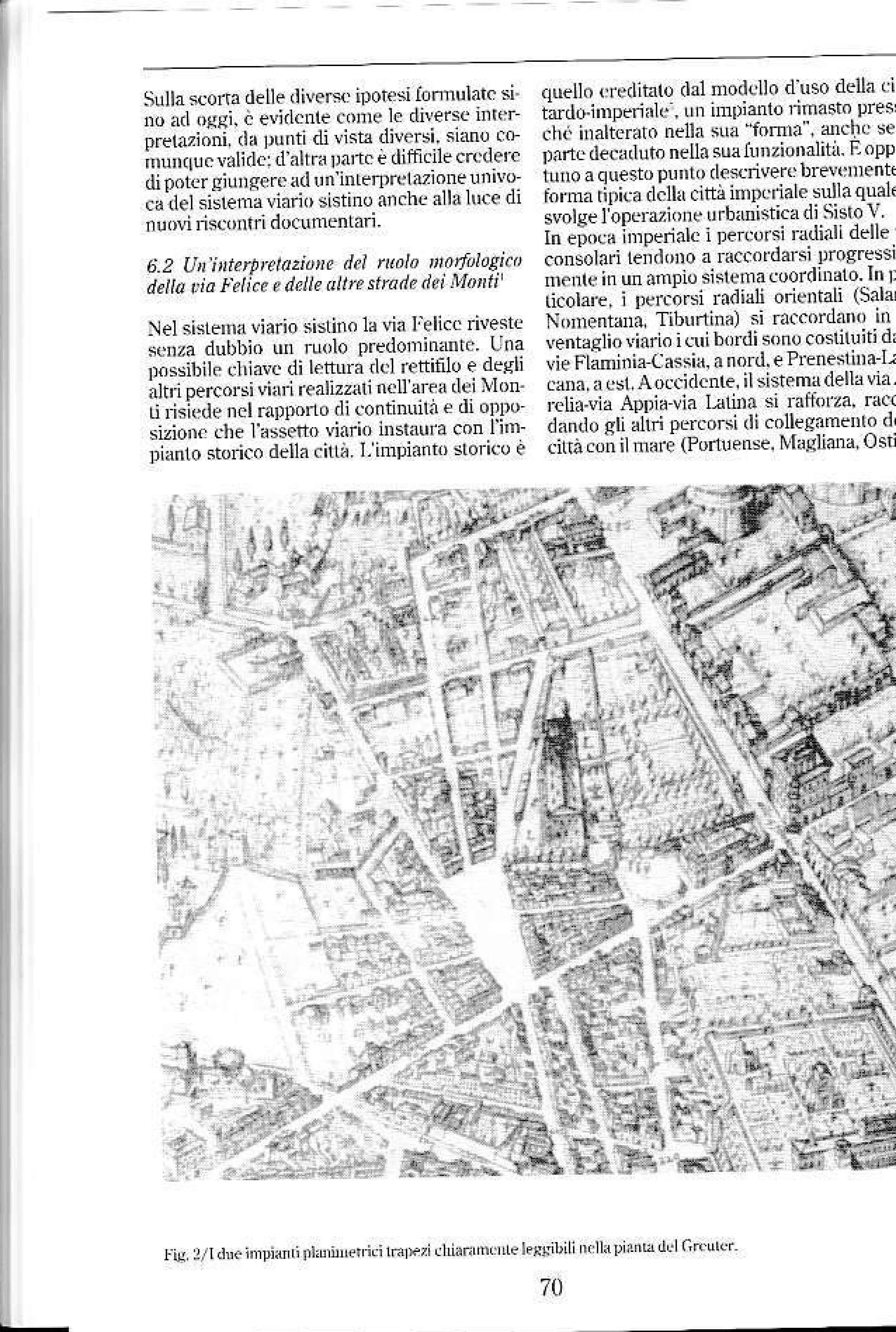
To the west, the system - made up of the Etruscan routes arriving at the ford on the Tiber and then merging into the final stretch of the Via Aurelia and the route of the Latin populations, the Via Latina, later downgraded by the construction of the Via Appia - was strengthened, linking the other routes connecting the city with the sea (Portuense, Magliana, Ostiense, Ardeatina). The two primary systems, western and eastern, pertaining to the vast area (they are road systems consisting of routes that reach the borders of the empire: Cassia Flaminia Casilina Aurelia and Appia), tighten the system of the Forums, giving rise to an overall structure with a double 'hyperbola' that constitutes the typical shape of the city.[This form creates an effective relationship between the territorial road system and the urban system of the central areas, i.e. the 'open' system of the Forums, which underlines the territorial dimension of the city. The form thus identified lapses in the Middle Ages; however, even if it is used differently, the urban road structure substantially maintains its original layout until the urban intervention of Sixtus V, who, in extreme synthesis, replicates the system of the double hyperbola with the terms and the basilica of Santa Maria Maggiore at its centre.[5]
Maurizio Crocco
[1] S. Muratori, R. Bollati, S. Bollati, G. Marinucci, Studi per un operante storia urbana di Roma.(Roma 1963)
[2] Giancarlo Cataldi, Per una scienza del territorio. Studi e note, (Firenze 1976)
[3] S. Muratori , op. cit. p.I,5
[4] G. Moneta, Roma: la struttura e la forma. In “Lineamenti del corso di composizione III” Dispensa n.6 DAAC Università La Sapienza. Roma (1985)
[5] M. Crocco., Roma, Via Felice. Da Sisto V a Paolo V, pp.68,69,70. (Roma 2002)
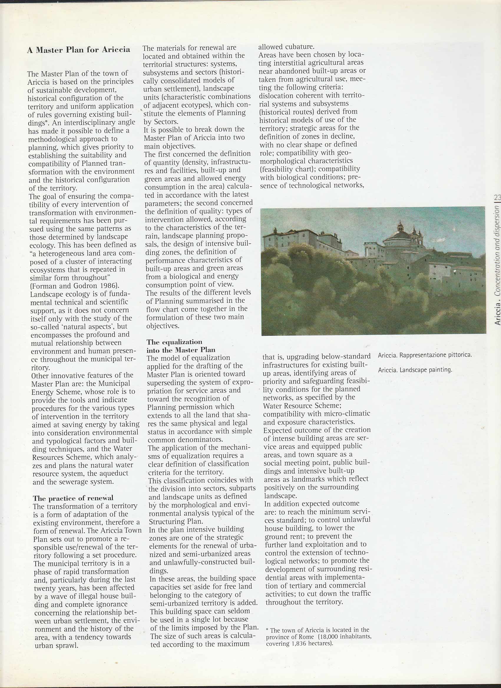
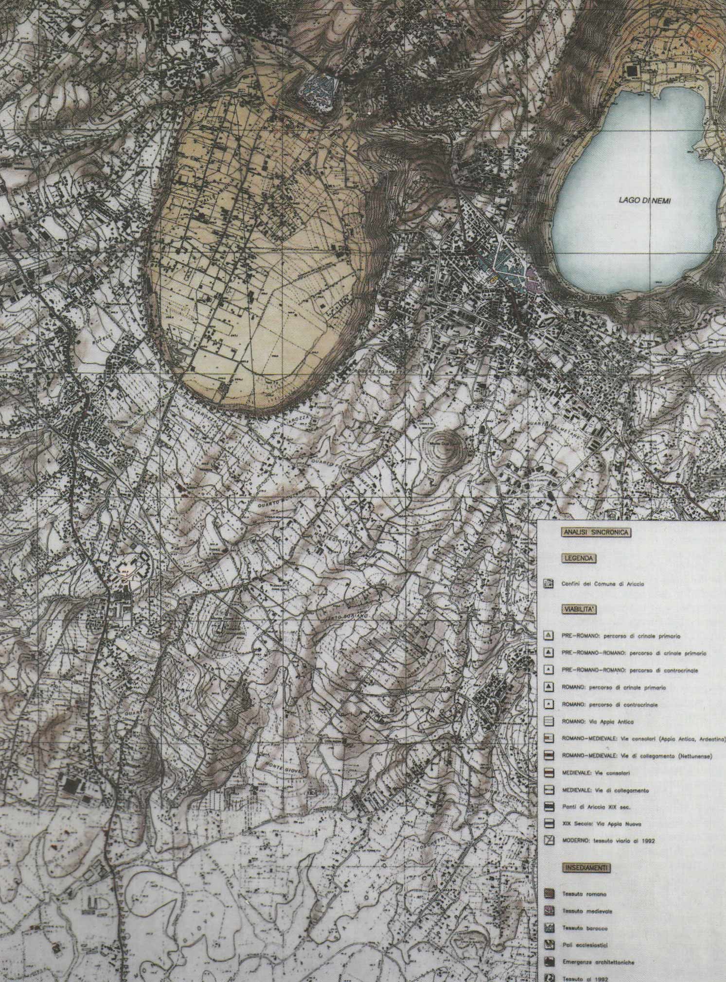
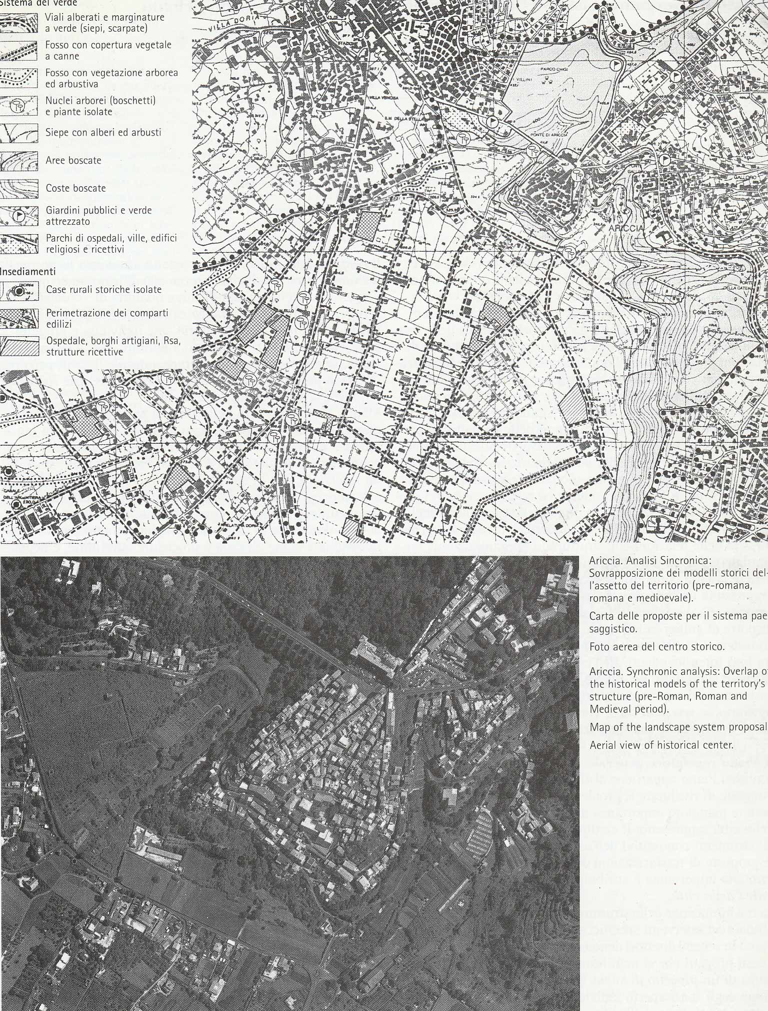
A Master Plan for Ariccia
Landscape Ecology,
Urban Planning,
Urbanism
1997, Frst Exhibition of European Town Planning
Volume: 1
Publication Date: 1997
Publication Name: Frst Exhibition of European Town Planning
The master plan of the town of Ariccia is based on the principles of sustainable development, hystorical configuration of the territory an uniform application of rules governing exsisting buildings
Roma, Via Felice. From Sisto V to Paolo V
Author Maurizio Crocco
ed.Kappa Roma 2002
The book Roma, via Felice da Sisto V a Paolo V, examines the vineyards of the Quirinale and the Pincio, affected by the opening of the Via Felice sistina in 1586. The unpublished notarial documents, the basic material for this study, mainly concern three properties affected by the profound transformation processes induced by the important event of the construction of the Via Felice in the urban history of Rome: the Grimani and Mattei vineyards, both at the Quirinale, and the Ferri-Orsini vineyard on the Pincio. Other properties are marginally affected by the study: the Ubaldini vineyard, the Sforza vineyard and palace, later Barberini, and the Este vineyard. From the analysis of notarial documents and other sources it is possible to derive a wealth of information useful for describing an important moment in the process of transforming the city of Rome. This study highlights in particular the ways in which land was parcelled out, the genesis of a new road system, the growth of a new building fabric, the subjects involved in this transformation process and, finally, the values of land and property rent in a newly expanding sector of the city. The study also highlights the relationship between the papal urban development programmes and private investment in the city, with the aim of integrating the history of the 'minor' building fabric with the well-known history of the city's major urban and architectural interventions.
Monitoring of the evolution of the built environment and its recovery with the help of the GIS tool
Monitoraggio dell'evoluzione dell'edificato e suo recupero con l'ausilio dello strumento GIS
Remote sensing and GIS applications in Landscape Research,
Town and Country Planning,
Urban Land Development and Management
The paper proposes the application, at an extra-municipal level, of a methodology based on the principles of development rights and on the historical morphological analysis of the territory. Using the GIS tool that allows monitoring the evolution of the building, it can deal the territory towards less environmental impact forms and allow access to network services and mobility. The methodology used by the authors in their contribution to the drafting of the PTPG of Latina and Viterbo allowed the classification of soils for the purpose of development rights of the provincial level that is propaedeutic to the territory restore that is characterized by widespread forms of settlement and often spontaneous. Note: paragraph 2 is edited by F. Paolo Di Giacomo; paragraphs 5.3 and 5.4 were handled by both authors; The remaining paragraphs are edited by Maurizio Crocco.
Historical Models (pre Roman, Roman, medieval)
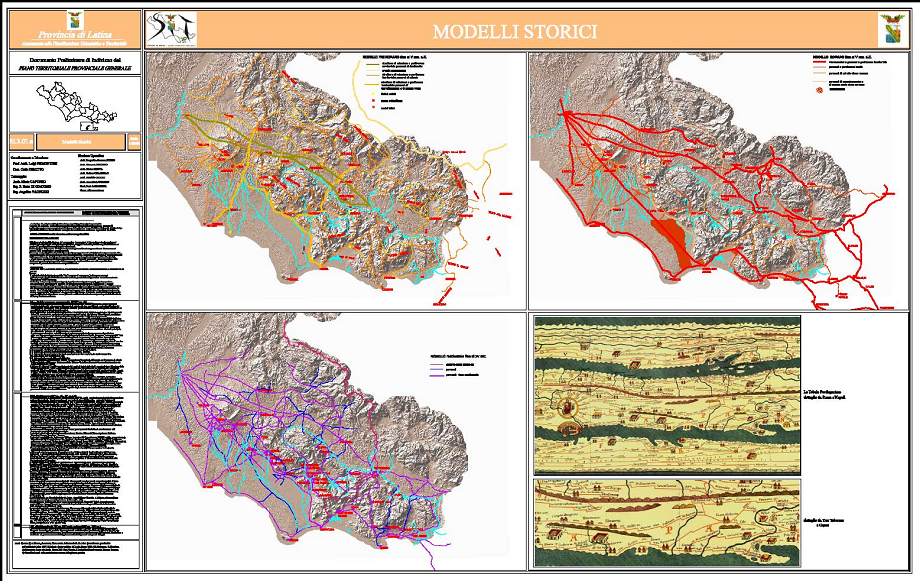
Morfological Systems
Territory Classes
Settlement and Morpho/Typological Systems
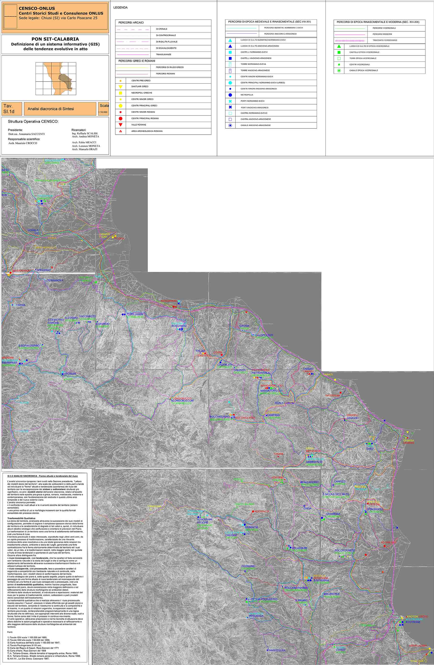
PON SIT CALABRIA: Definition of a Geographical Information System of current evolutionary trends
G. Moneta, M. Crocco, A. Moneta
READING THE HISTORICAL PATTERNS OF THE TERRITORY
THE LANDSCAPE
The reading of the historical models of the territory takes into account their relationship with the original landscape and the various transformations that have taken place, i.e. the landscape is understood here as the place of the transformations.
DIACHRONIC ANALYSIS OF THE SHAPE AND TRANSFORMATIONS OF THE TERRITORY OF THE GREEK SILA
The history of the territory, analysed through the succession of its "configuration models", makes it possible to grasp the complex historical depth of the form of the territory and the characteristics of degradation of the relative values and, therefore, to identify some strategic objectives that converge and orient the forecasts of the urban plans.
DYNAMIC LAND CONFORMATION PROCESSES
First of all, the 1888 IGM cartography at a scale of 1:100,000 was adopted as the basic cartography to study the various "configuration models" of the territory.
This base provides an immediate image of the "natural structure" which is configured as the primordial matrix within which the lines of anthropic penetration of the area and the dislocation of the various polarities are explained.
In particular, the following have been analysed
- the pre-Greek and Greek model (8th century B.C. - 6th century B.C.);
- the Roman model (6th century BC - 5th century AD);
- the medieval model (6th century - 15th century);
- the Modern Model (16th century - 19th century);
- the Contemporary Model (20th cent.).
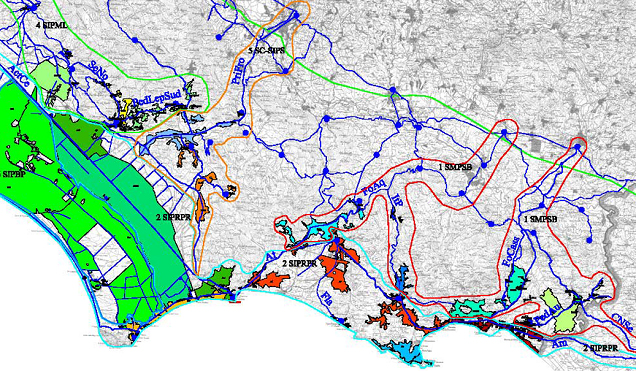
SYNCHRONOUS ANALYSIS - Current and trend form of re-use
The synchronic analysis re-proposes the themes developed in the previous section, "Reading the historical models of the territory", at the scale of subsystems and parts and tends to identify the current and tendential (spontaneous) "form" of the re-use of the territory with the superimposition of the most significant structural systems and subsystems, i.e. the historical models of the diachronic analysis,
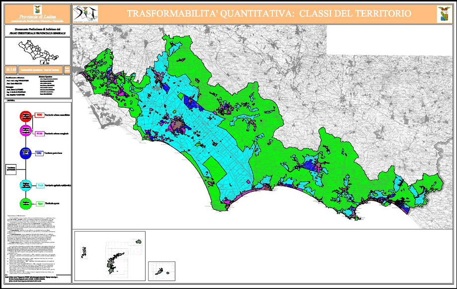
QUANTITATIVE TRANSFORMABILITY
SOIL CLASSIFICATION scale 1:50,000
This study subdivides the territory under examination into classes and relative subclasses. The subdivision is based on the de facto and legal status and on the structural choice which foresees the maintenance of agro-forestry uses or the consolidation and passage to urban uses of the classes of land identified. The classification of the territory is useful to determine, already at the stage of drafting structural plans, a specific potential building regime for each class and sub-class (quantitative transformability), while the morphological partition determines specific qualitative preservation-transformation rules for each sub-part
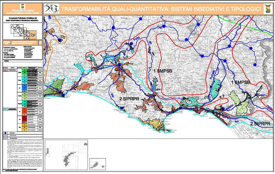
QUALITATIVE TRANSFORMABILITY
The history of the territory, analysed through the succession of its configuration models, makes it possible to grasp the complex historical depth of the form of the territory and the characteristics of the degradation of these values and, therefore, to identify some strategic objectives that flow into and guide the forecasts of the urban plans. The analysis of qualitative transformability has led to the identification of three systems of relations with territorial relevance, i.e. parts of the territory by comparing and overlapping the maps of Historical Models
THE SYNTHESIS - QUALITATIVE-QUANTITATIVE TRANSFORMABILITY
STRATEGIC LEVEL, PROJECT ACTION AND OPERATIONAL LEVEL
PLANNING BY PARTS
In the type-morphological analysis and in the Environmental System Study, the territory of Sila Greca is divided into Parts and corresponding Landscape Units.
Each of the Parts of the territory, considered as a type-morphological unit of the settlement system, is treated in the perspective of an affirmation of its "form and roles" characters, of its relations with the other Parts through the systems and subsystems of relations and the structuring green system.
Also the verification of services is carried out within the single Parts in relation to classes of services that, in the programmatic choices of the planning, are considered pertinent to the single part.
The planning by Parts foresees for them a section of directives with forecasts concerning the morpho-typological order of the settlement system, the infrastructural functional system and the reorganization of the ecological characteristics of the Part.
Syncronyc Model
CIRTER JOURNALS
INTER-UNIVERSITY CENTRE FOR TERRITORIAL RESEARCH
THE SHAPE OF TRANSFORMATIONS IN THE TERRITORY OF UMBRIA
G. Moneta
Diacronic Analisys